The risk of ground movements, in particular fast-changing vibrations, occurs in all post-mining areas in Europe. Its intensity and probability of occurrence depends on many various factors. Such events have a strong impact on the formation of negative opinions about underground mining. Therefore the main idea of project proposal is to gather and analyze the data from selected coal fields in which both the deformation and seismic events are observed in post-mining phase, analyze them and design a proper, hazard monitoring systems. The data from these systems will be able to be shared with local communities.
Basing on the state of the art and the identification of the crucial needs, the project has three main objectives:
- the first one is to analyse national experiences of main European countries with coal mining legacy (Poland, France, Germany, Czech Republic) using same tools and methodology and formulate transnational criteria how to deal with post mining hazard manifesting as seismic tremors,
- the second objective is to examine and choose update methods and plans for long term monitoring of post mining lands in order to mitigate seismic risk during and after coalmine closure,
- the third one, to help the mine regions to develop their economic and social activities taking into consideration the development of dynamic risk maps.
The research scope of the project goes far beyond a simple relation between seismicity, rainfall and the process of mines flooding. It uses new techniques and systems for observation of the earth dynamics transformed by mining and climate change. Therefore, the project implementation will bring real benefits to users of post mining lands and help to improve the mine closure procedures.
The data sets from four research sites will be analyzed regarding to geological and mining conditions of test field sites as well as to other natural and induced factors such as: basins evolution, tectonics, hydrology, climate changes, natural seismicity. Multi – variant analysis of the data sets will enable to formulate criteria how to assess the reasons of long-term post mining ground movements and distinguish the geological from mining (anthropogenic) ones. The final result of the project will be a comprehensive book (transnational guidelines) which can be used by mining operators, mine authorities, consultants, potential investors and decision-making bodies.

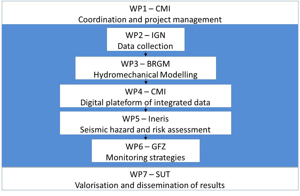
The following topics will be developed in the project based on the structure of the project.
- WP2: Elaboration of a data-base on well documented case studies of post-mining districts known by the partners of the project. A data-base should include seismicity (induced and natural if any), water level changes (water level in-situ measurements), surface deformations (subsidence, discontinuous), in a rock-mass strains (gravity changes) and metadata about geology, tectonics and mining exploitation history.
- WP3: Modelling of the rock mass mechanical and structural response for the water loads during flooding (to be performed for two coal basins – France and Poland). Validation of models.
- WP4: Development of a digital platform on post-mining areas in Europe prone to seismicity and rock mass movements during and after flooding.
- Elaboration of a methodology of integrated study to evaluate the post-mining earthquake hazard – susceptibility of a coal basin to induce seismic events.
- Study of the mechanisms of induced seismicity in post mining regions.
- Study of the interaction between natural and induced seismicity in post mining regions.
- WP5: Hazard and vulnerability assessment: Elaboration of criteria of hazard rating.
- WP6: Monitoring strategies of areas with high hazard.
- WP7: Dissemination of the main results through different tools and media, that increase the role of the Europe to manage the abandoned coal mines.

