
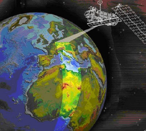
InSAR SATELLITE RADAR INTERFEROMETRY
Satellite Radar Interferometry InSAR is a remote sensing technique used to obtain information about the Earth’s surface in a strictly defined period of time. This range, currently in the scope of several to a dozen of days, depends on the plan of the satellites flights. Using repetitive satellite raids, armed with specialized transmitting and receiving devices SAR (Synthetic Aparature Radar), this technique enables the scanning of the Earth’s surface over the area of many thousand km2 practically in one moment of time. The effect of scanning, carried out by means of a radar wave sent towards the Earth, is the so-called Radarogram (raster image). During the recording, information about the intensity of the radar wave reflection from the Earth’s surface is saved in individual pixels of the image and the phase of this signal at the time of it arriving back at the receiver.
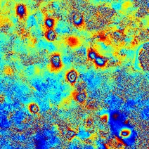
The compilation of two radarograms of the same area, taken over a specific time interval, allows to calculate the phase difference of the radar signals in corresponding pixels. This value, with the knowledge of the wavelength, is processed numerically, obtaining information about vertical movements of the terrain surface. This information is carried by the Interferogram – a product of computer processing of a pair of radarograms.
The interferogram shows, in an appropriately selected color scale, the phase difference of radar signals in corresponding pixels of the set pair of radarograms. The zones of vertical ground surface movements (e.g. depressions) on the interferogram appear in the form of characteristic color stripes with a repeating sequence of colors. Depending on the color palette used and the radar wavelength used to scan the terrain, each color corresponds to a vertical displacement with a specific, fixed value. The radar wavelengths currently used to scan the Earth’s surface can detect changes in altitude in the sub-millimeter range.
The basis for the correct interpretation of the phenomena recorded by the InSAR method is the good quality of the interferograms. It depends mainly on the coherence of the radar images used. Coherence is a parameter that determines the proportion of differences of the conditions of radarograms taking that occurred in the environment in the period between successive imaging. It is adversely affected by strong changes in soil moisture, forest land development or too much difference of the position of the satellite between successive raids.
The use of the InSAR method in the study of altitude changes of the terrain surface allows for the obtaining spatial information without the need to conduct works in the areas of deformation. The surface nature of the acquired data is the main advantage of the method. Possible access to point information obtained, for example, from classical measurement methods, may greatly facilitate the interpretation of processed images. Thus, they increase the quality and credibility of the obtained final results.
Another important factor is the possibility of acquiring and processing archival SAR images, stored in the resources of the European Space Agency, containing information on changes in the surface of the area in the past years (since 1991).
Interpretation of the data contained in the interferogram comes down to the appropriate digitization of the raster image. Digital digitization of contour lines of the interferometric image of vertical displacements leads to receiving a contour line map of depression increments. This process enables spatial modeling of altitude changes of the terrain surface.
Periodic subsidence trough (formed in the time interval between two SAR images) are obtained in the coordinate system of the digital terrain map. This result enables the determination of the boundaries (range) of the current threat to the area in which the deformation process takes place or took place in the past.

